Solutions
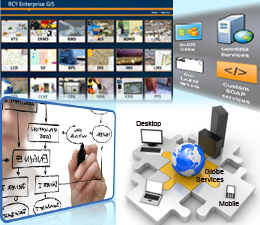
GIS integration into a modern enterprise IT environment is challenging in today’s business world of leveraging investments made in desktop, server, web services and state-of-the-art mobile technologies to support business operations and a mobile workforce.
By leveraging key skills of our highly qualified professionals, TechButtons provides end-to-end integration solutions specific to the clients requirements.Our integration solutions are aimed at creating an integrated business environment with automated processes that consolidate the disparate data and systems quickly and seamlessly.
Extracting the maximum value from a GIS requires more than just publishing map layers to a web-mapping site. GIS delivers real value when integrated with an enterprise's traditional line-of-business data and applications.
TechButtons provides a range of Integration solutions for a variety of industry verticals and implements integration solutions based on variety of middle-ware products for all kinds of integration scenarios such as for CRM, ERP and others.
TechButtons integration solutions consist of:
- GIS and CRM & ERP integration
- GIS and Electronic Document Management System (EDMS)
- GIS and e-Business/e-Government Integration
- GIS and Legacy Database Integration
TechButtons for its valued clients in KSA have successfully integrated GIS throughout the organization in a way that business clients can effortlessly access geospatial data derived from relevant backend technologies.
A utility engineer is critical about the information on where utilities have been installed, what kind of materials was adopted and how the utilities affect the rest of the managed environment. Such information is essential in utility planning, design and analysis, maintenance, damage prevention etc.
With GIS technology, these utility information are mapped smartly into database and through GIS services, the data can be queried for day to day operations, maintenance and other activities.
TechButtons with its vast expertise in utility data mapping projects has established its credentials in the kingdom and Middle East in providing solutions on accurate utility asset mapping, field survey verification and utility application development at enterprise level.
Our services include GIS mapping, GIS application integration and development in a customized manner to suit the requirements of Utilities.
We undertake customized or spatial systems integration on the different horizontal and verticals of utilities like:
- Electric Distribution / Transmission
- Street Light network
- Telecommunications network
- Water and waste water
- Gas network
- Irrigation and Storm drainage network
Our skilled professionals have the knowledge to blend the technologies of digital mapping from variety of sources including CAD as-built, raster images, GPS field data, existing hard copy maps and underground survey data leading to GIS database creation.
- Flexible, dependable and Open architecture
- RIA based interface
- Scalable design for future updates
- An analysis tool for future Master plan for utility networks
- Efficient tools for network tracing, fault finding, valve isolation, customer indexing
- Pumping, lift station and source to sink analysis
- Conduit status analysis
- Report generation for statistical analysis
GIS integrates software and data for managing, analyzing, and displaying all forms of geographically referenced information associated with developing and managing infrastructure. These can be fulfilled by operating spatial information stored in the database.
In today's connected world, GIS solutions are becoming an increasingly important area for realizing effective land management systems for many municipal governments across the globe. Visualization of land information is also the key to decision making in selection of sites for facility planning, zoning, density classification etc.
TechButtons leverages GIS technology through developed integrated system dealing with land management process and procedure for land investment, land allocation, land classification, land record maintenance and zoning.
The developed land based system offers the following:
- Complex Geodatabase based on customized data models
- Land investment system for investors
- Land allocation system for different uses
- Land Coordination diagram and deed documentation
- Density classification system based on land holding
- Decision support tools for master planning activities
- Data Integration and development of Enterprise GIS Solutions
Timely, accurate information, easily accessed and capable of being shared across federal, state and local political jurisdictions is fundamental to the decision making capability of those tasked with the homeland security mission. But without the real-time ability to quickly visualize activity patterns, map locations, and understand the multi- layered geospatial context of emergency situations, homeland security will not be achieved.
The current state of geospatial information technology can provide decision-makers the data they require to confidently confront a wide variety of threats including natural disasters, terrorist attacks, sabotage, and similar crisis. However, the current implementation of that technology, across all the federal, state and local agencies and jurisdictions necessary to fully coordinate an effective response is seriously lacking in specific areas.
As the concept of Homeland Security becomes infused into the work-a-day pattern of government and the everyday life of our citizens, decision makers will greatly profit from the crisis management "edge" that GIS provides. Homeland Security leaders should understand and implement the policy changes necessary to fully realize this technology's capability, and make the management decisions necessary to implement it on a national basis.
Tracking solutions help you monitor the location and movement of objects in real time. Objects that can transmit their geographic location via Global Positioning Systems (GPS) or similar technologies can be dynamically tracked on a display map that can be shared via the Internet or intranet.
Analytic features enable you to trigger an action based on object's location relative to other geographic features, such as triggering an alert when a vehicle or cargo moves out of its service area.
With automatic vehicle location (AVL) tracking and a GIS-based display, dispatchers can visually relate mobile unit locations to destination locations. When live information or video feeds are incorporated into the map-based display, dispatchers can also keep an eye on the latest weather and traffic developments.
Electronic Governance (e-governance) involves the automation or computerization of existing paper-based procedures that will prompt new styles of leadership, new ways of debating and deciding strategies, new ways of transacting business, new ways of listening to citizens and communities and new ways of organizing and delivering information.
E-governance is tool by which citizens can communicate with Government. The basis for e-Governance is fusion of information with communication technologies (ICT) supporting and transforming the governance by processing and communicating data in the field of geographic sphere.
User friendly GIS solution plays an important role in planning, developing and implementation of Government programs & projects. GIS and ICT together have potential to reach the masses and include them in governance process.
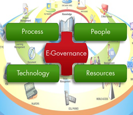
The key to e-government is the establishment of a long-term, organization-wide strategy to constantly improve operations with the end in view of fulfilling citizen requirements by transforming internal operations such as staffing, technology, processes and work flow management.
E-Governance functions include planning, preparation and approval of plans, management of existing infrastructure and restructuring of facilities. It has been observed that nearly 80% of government data is represented in spatial format. In local government, city planners view maps for development plan; engineers require information on utilities to forecast how serving a new colony will affect overall service; and the estate office updates data with measurements taken from a recent survey.
TechButtons is helping several Government organizations around the Kingdom to use our GIS tools in collaboration among various government departments for building a unified and standard geospatial data infrastructure.Our applications are the linking factor that enables the delivery of shared services, reducing costs, and improving decision-making.In addition to these, our ERP solution deployed in the kingdom improves the efficiency by sharing data between various Govt. organizations and departments.
GIS is becoming a vital tool in healthcare applications covering database management, planning, risk assessment, service area mapping, location identifications etc.
As a decision support tool, GIS improves understanding of the situation, what is needed, and how to intervene with prevention and mitigation strategies when necessary.
GIS would assist in better linking of environmental, demographic and temporal factors with the health issues to understand causes for such health hazards.
TechButtons have developed HealthGIS, a user-friendly data management and mapping system customized specifically for agencies and public health users. The system facilitates data standardization, collection and updating of data on epidemiology and on interventions and provides immediate visualization of data in the form of maps, tables and charts. The system is based on open source tools and technologies.

GIS has been recognized as an essential tool in various phases of emergency management such as preparation, mitigation, response, and recovery from disasters and emergency events.
Emergencies occur anywhere, at any location, at any time and in different ways leading to risk. As such emergency situations require rapid response. Also proper emergency management services depend on accurate data from a variety of sources. The appropriate data has to be gathered, organized, and displayed logically to determine the size and scope of emergency management programs.
To manage the situation, GIS based Emergency Management System (EMS) is required to support the responders for quick and efficient emergency care during emergency situation.
TechButtons have developed EMS for client in KSA to help it right from assets information and ground facts to tracking, virtual planning and response to emergency and recovery.
EMS has the following features:
- Combination of geospatial portal and decision supporting tools
- Information and planning tools
- Analysis tools
- Damage control and Virtual Analysis tool
- Disaster analysis and decision tools
- Live footage with patrol cars and locations
- VOIP connection for decision makers
- Virtually connected with police, fire, hospital and traffic departments
- Automatic mass sms / emails to respective personals